Listen
As heavy rains move into the Northwest, geologists are watching the Oregon side of the Columbia River Gorge. This summer’s wildfires have made slopes that are already prone to landslides even more treacherous.
Bill Burns is a top engineering geologist for the state of Oregon and an expert on landslides. He’s worried about the Gorge’s burned areas—plus rocks, mud and a healthy side of rain. He just knows too much.
In 1996, mud buried I-84 and the train tracks near the community of Dodson and flooded into the Columbia halting river traffic. A Prius-sized basalt boulder came down from the hillsides above.
And it’s still there. A sort of ominous reminder.
“That’s pretty big right?” Burns said. “So, imagine something like that coming at you at 30-40 miles an hour, inside of basically a wall of mud. Not much is going to survive.”
Burns would rather not be here.
“Definitely made me nervous,” he said.
Past landslides still haunting the Gorge
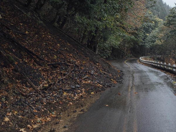
Burns said the Gorge is extra prone to landslides. There are basalt cliffs mixed with softer soil, all married with huge rainfall.
On a deeply-scratched field iPad, Burns showed off a map of the area. The slopes are lit up in bright colors. They indicate landslides have happened all around here before.

And in the last decade, with new technology, scientists are seeing way more old landslides than they ever knew existed.
Old landslides are a prime indicator of where new slides can happen. And now many of those same areas have been roasted by this year’s wildfires. Little remaining vegetation means the ground has no shelter from the rain -- and it might not drain fast enough. And that means the land may come sliding down.
“There are thousands of them in Oregon, so can’t name them all,” Burns said.
‘You might come here and think it’s safe’
The lodge is still closed at Multnomah Falls. So is the historic highway that gets people there. Wildfires burned off much of the moss and other vegetation that kept the basalt cliffs around the falls stable.
Rachel Pawlitz with the U.S. Forest Service said it’s not immediately clear how dangerous this whole area is.
“Oneonta is a good example of how you might come here and see some green trees and think it’s safe,” she said. “But higher up in the watershed it’s one of the most badly burned areas which is why we know that it’s got that risk for debris jams, floods and other things to come down through the creek.”
» Why moss is central to the danger at Multnomah Falls
But perhaps most worrying is where the rocks meet the road. In a spot called Shellrock Mountain, alongside Interstate 84 in the Columbia Gorge, a tide of recently-fallen rubble appears tumbled. Like half-blended margarita ice cubes. All the corners knocked off.
Protecting I-84
Stephen Hay is an engineering geologist for Oregon’s Department of Transportation. It’s his job to keep this major east-west corridor safe from landslides, rockfall and debris flows. About 23,000 vehicles pass through each day. Another 4,500 on the Columbia River Highway.
To protect the highway, the state and feds have piled massive sandbags along one edge and closed one lane to traffic.
But seeing what the mountain is capable of, you wonder whether its enough. Take the recent “tree toboggan.”
“We had a tree that was on fire come down the slope and ended up going through our retaining wall along here,” Hay said.
Hay said that burnt tree picked up so much speed it went through all the eastbound lanes of I-84 and pushed the center barrier too.
Hay flies through the Gorge with a helicopter pilot at least once a month on the lookout for fresh problem areas. Falling trees, stones and mud don’t give much warning. And they will be a problem for years now.
» Can area businesses handle another disaster?
So far, ODOT has spent nearly $500,000 just through September on fire fixes. Shellrock Mountain is just one spot on the interstate. There are thousands of burned acres in the Gorge.
And more rains are coming.
Copyright 2017 Northwest News Network. To see more, visit Northwest News Network.

Related Stories:

Could Artificial Intelligence Help Boost Salmon Recovery?
Sixty different entities in a salmon recovery project have been collaborating for nearly a decade, trying to solve the mystery of why so many of the juvenile fish die after they swim out to the ocean. Can artificial intelligence help?
Read More » Bellamy Pailthorp January 3, 2018
Rural Washington Counties Seek More State Money With Tax Revenue Hard To Come By
County governments are pushing back against Washington state over who should pay for certain services. The counties are upset the state has imposed a number of requirements on county government without additional funding.
Read More » Anna Boiko-Weyrauch January 2, 2018
Jay Inslee Stays Mum On Whether He’ll Run For President
Washington Governor Jay Inslee is downplaying talk he might run for president in 2020. In an interview last week, Olympia correspondent Austin Jenkins asked Inslee if a bid for president was even in the realm of possibilities.
Read More » NWPB News January 2, 2018